
CITY OF SHOW LOW ORDINANCE NO. 2026-06
AN ORDINANCE OF THE MAYOR AND COUNCIL OF THE CITY OF SHOW LOW, ARIZONA, AMENDING THE ZONING CONDITIONS OF ORDINANCE NO. 2021-07 ON ASSESSOR PARCEL NUMBERS 210-04-031, -033, -042, -044, -032A, -037A, -039A, -045A, -046A, -049A AND -050A
RECITALS:
WHEREAS, Chapter 19.30 of the Zoning Ordinance of the City of Show Low establishes zoning districts within the City of Show Low as shown on the map entitled "Zoning Map of the City of Show Low" which is incorporated in said Chapter 19 by reference and empowers the Council to make changes in said zoning districts; and
WHEREAS, on November 1, 2016, Council adopted Ordinance No. 2016-03 that rezoned the property indicated on Exhibit A, attached hereto and made a part hereof by this reference, including conditions placed thereon; and
WHEREAS, Ordinance No. 2016-03 has since been amended by Ordinance No. 2019-03 and Ordinance No. 2021-07 based on requests of the property owner; and
WHEREAS, the property owner, Ryan Ellsworth of Paradise Acres, LLC, has submitted a request to amend condition 8 of the zoning conditions to increase the number of allowed units from 58 to 66;
WHEREAS, the Planning and Zoning Commission, at its Regular Meeting of October 13, 2026, held a public hearing on the request for an amended zoning condition, herein described, and recommends approval of the request to increase the total number of apartments allowed from 58 to 66; and
WHEREAS, A.R.S. §9-802 permits municipalities to enact the provisions of a code or public record in existence without setting forth such provisions in full text as long as the adopting ordinance is published in full text, and one paper copy is filed with the City Clerk and an electronic copy is accessible on the City’s website, with both made available for public use and inspection; and
WHEREAS, City staff has identified such documents herein, and it is the intent of the City to declare these documents public records, on file in the office of the City Clerk.
ENACTMENTS:
NOW, THEREFORE, BE IT ORDAINED by the Mayor and Council of the City of Show Low, Navajo County, Arizona:
Section 1
That certain documents titled "Zoning Map of the City of Show Low," “Exhibit A Subject Property Map,” “Exhibit B Legal Description,” and “Exhibit C Conditions” , of which at least one paper copy is on file with the City Clerk and one electronic copy is maintained, in compliance with A.R.S. §44-7041 and 9-802, is hereby declared to be a public record, and shall be made available for public use and inspection, and is adopted by reference as though fully set forth herein.
Section 2
The map entitled "Zoning Map of the City of Show Low," which is incorporated by reference into the Zoning Ordinance of the City of Show Low by Chapter 19.30.020 of said ordinance to show the location boundaries of the zoning districts as said location and boundaries are shown on Exhibit A; to have the effect of amending the zoning conditions of the property legally described on Exhibit B, known as A.P.N.s 210-04-031, -033, -042, -044, -032A, -037A, -039A, -045A, -046A, -049A AND -050A, attached hereto and made a part hereof by this reference, with the conditions of the zone change indicated on Exhibit C, attached hereto and made a part hereof by this reference.
Section 3
All ordinances and parts of ordinances in conflict with the provisions of this ordinance or with any part of the amendment adopted herein by reference are hereby repealed.
Section 4
If any section, subsection, sentence, clause, phrase, or portion of this Ordinance adopted herein is, for any reason, held to be invalid or unconstitutional by the decision of any court of competent jurisdiction, such decision shall not affect the validity of the remaining portions thereof.
PASSED AND ADOPTED by the Mayor and Council of the City of Show Low, Arizona, this 28th day of October, 2026.
/s/ John Leech, Jr., Mayor
ATTEST:
/s/ Rachael Hall, City Clerk
APPROVED AS TO FORM:
/s/ Anna M. Atencio, City Attorney
EXHIBIT A
Subject Property Map
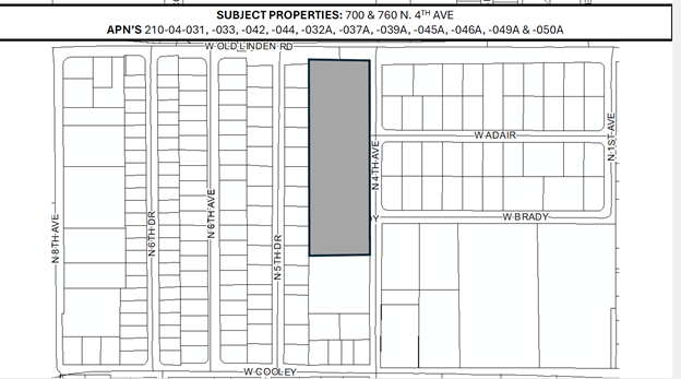
EXHIBIT B
Legal Description
NE ¼, Section 19, Range 22 E, Gila and Salt River Base and Meridian, Navajo County, Arizona. Commencing at the N.E. corner of said Section 19, thence S 89 degrees 26'48"W 1351.2 feet, thence S 0 degrees 11 '08"W 17.30 feet to the point of beginning, thence S 0 degrees 11'08"W, 809.70 feet, thence N 89 degrees 47'26"W 254.00 feet to a point in the east line of Linda Vista Subdivision, thence N 0 degrees 11 '08"E 809. 70 feet, thence S 89 degrees 47'26" E 254.00 feet to the point of beginning. Otherwise described as the Paradise Acres subdivision.
EXHIBIT C
Conditions
1. All development shall comply with all applicable federal, state, and local requirements.
2. Development shall comply with R2-7 (Single-Family and Multiple-Family Residential, 7,000 square feet) requirements including open space and screening requirements from adjacent properties. The required screening shall be constructed prior to commencing constructing the adjacent buildings.
3. The project shall demonstrate substantial conformance with the submitted site plan, including setbacks from adjacent properties.
4. The developer shall install sidewalks and curb or other pedestrian way on the west side of 4th Avenue as designed and determined by the city engineer, with the City responsible for drainage in the public rights-of-way and developer responsible for all drainage issues on the interior of the subject property.
5. No windows shall be placed on second stories overlooking the west property boundary.
6. Parking areas shall be paved and lit in accordance with City Code.
7. All manufactured homes/mobile homes and similar dwelling units located on the west property boundary shall be removed within two years from the date of approval of this zone change. Any additional extensions to this timeframe will require City Council approval, with notice provided to the neighbors.
8. The project shall be restricted to a maximum of 58 66 apartment units.
9. Painted or stained solid masonry or concrete fencing shall be required around the perimeter of project with vegetative screening consisting of a minimum of five bushes and four trees per building substituting for the required wall on the east side of the subject property along North 4th Avenue. The required solid masonry or concrete fencing along the west and south property lines shall be installed by July 1, 2022.